Current Conditions
♦
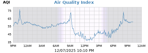
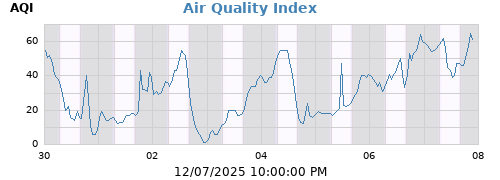
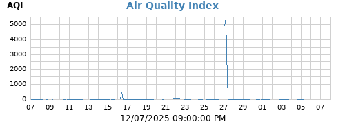
| Air Quality | 33 GOOD |
| PM 2.5 | 6 µg/m³ |
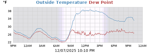
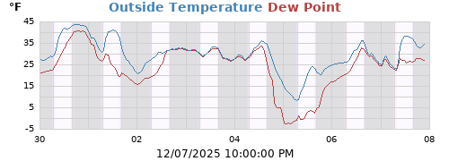
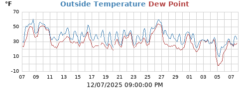
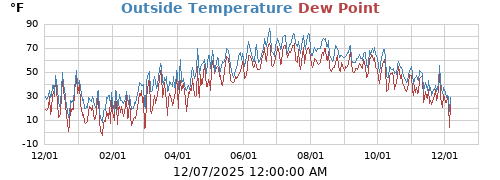
| Outside Temperature | 82.2°F |
| WBGT (EST.) |
78.0°F
Low Risk
|
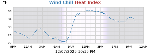
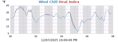
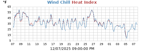
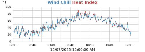
| Heat Index | 85.5°F |
| Apparent Temperature | 87.7°F |
| Humidex | 96.4°F |
| Dew Point | 68.6°F |
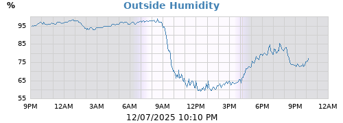
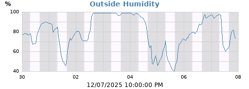
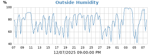
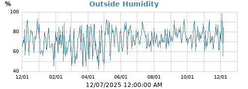
| Outside Humidity | 63% |
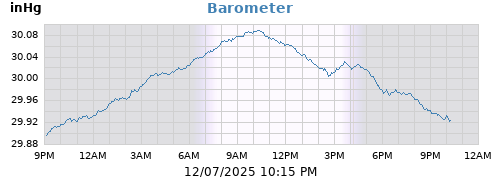
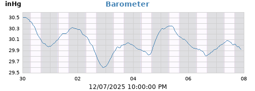
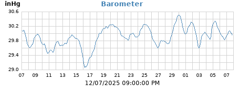
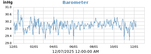
| Barometer |
29.916 inHg (-0.025)
Falling Slowly
|
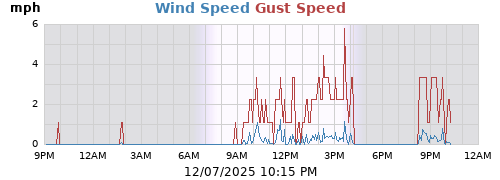
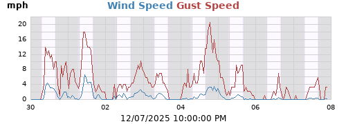
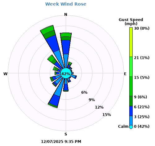
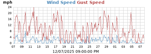
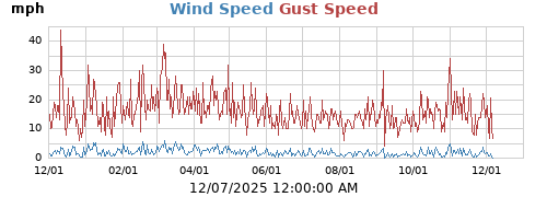
| Wind | 3 mph SW (217°) |
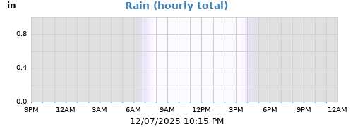
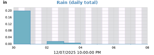
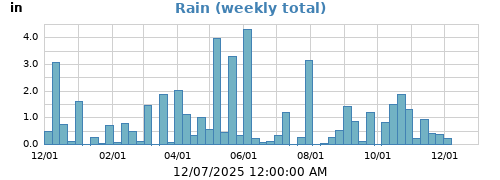
| Rain Rate | 0.00 in/h |
| Rain Today | 0.00 in |
| Rain Yesterday | 0.00 in |
| Storm Rain | 0.00 in |
| Last Rain |
07/30/2026 06:20:00 PM
2 days, 21 hours, 55 minutes ago
|
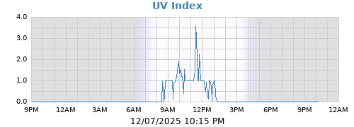
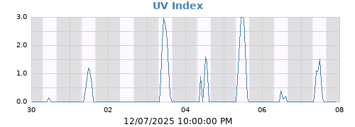
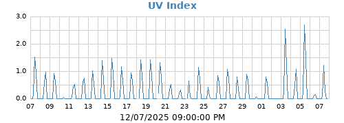
| UV Index | 2.0 |
| ET Today | 0.11 in |
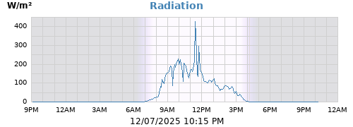
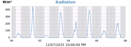
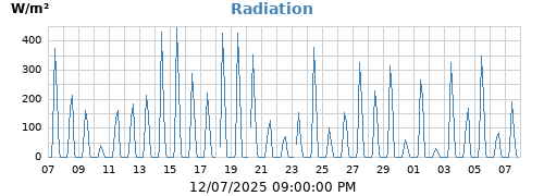
| Radiation | 297 W/m² |
Forecast
♦
| Today |
Week |
Month |
Year |
Rain Year |
||
|---|---|---|---|---|---|---|
| Outside Temperature |
85.5 70.0 |
85.5 70.0 |
86.7 63.9 |
96.3 -6.9 |
96.3 -6.9 |
°F |
| WBGT |
89.3 69.4 |
89.3 69.4 |
89.3 63.8 |
92.8 -7.1 |
92.8 -7.1 |
°F |
| Air Quality Index |
50 28 |
50 28 |
53 27 |
174 0 |
174 0 |
AQI |
| PM 2.5 |
9 5 |
9 5 |
10 5 |
88 0 |
88 0 |
µg/m³ |
| PM 1.0 |
13 6 |
13 6 |
13 6 |
104 0 |
104 0 |
µg/m³ |
| PM 10.0 |
18 7 |
18 7 |
18 7 |
119 0 |
119 0 |
µg/m³ |
| Heat Index |
91.7 71.2 |
91.7 71.2 |
92.2 64.6 |
106.5 -6.9 |
106.5 -6.9 |
°F |
| Wind Chill |
85.5 70.0 |
85.5 70.0 |
86.7 63.9 |
96.3 -6.9 |
96.3 -6.9 |
°F |
| Dew Point |
75.3 67.4 |
75.3 67.4 |
75.3 63.5 |
76.6 -16.3 |
76.6 -16.3 |
°F |
| Outside Humidity |
97 56 |
97 56 |
99 49 |
99 16 |
99 16 |
% |
| Barometer |
29.979 29.911 |
29.979 29.911 |
29.979 29.878 |
30.701 29.263 |
30.701 29.263 |
inHg |
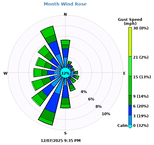
| Max Wind |
17 231 |
17 231 |
17 231 |
36 206 |
36 206 |
mph ° |
| Average Wind | 2 | 2 | 1 | 1 | 1 | mph |
| RMS Wind | 3 | 3 | 2 | 2 | 2 | mph |
|
Vector Average Vector Direction |
2 189 |
2 189 |
1 186 |
0 74 |
0 74 |
mph ° |
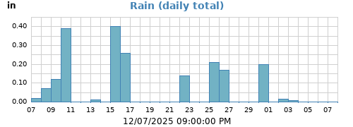
| Rain | 0.00 | 0.00 | 0.00 | 16.70 | 16.70 | in |
| Rain Rate | 0.00 | 0.00 | 0.00 | 1.56 | 1.56 | in/h |
| Evapotranspiration | 0.11 | 0.11 | 0.27 | 17.72 | 17.72 | in |
| UV Index | 10.0 | 10.0 | 10.0 | 10.0 | 10.0 | |
| Radiation |
1182 0 |
1182 0 |
1182 0 |
1182 0 |
1182 0 |
W/m² |
| Lightning Strikes | 0 | 0 | 1 | 456 | 456 | |
| Lightning Distance |
5.0 5.0 |
5.0 5.0 |
5.0 0.6 |
24.9 0.6 |
24.9 0.6 |
miles |
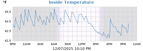
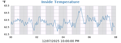
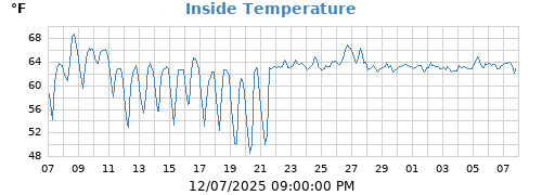
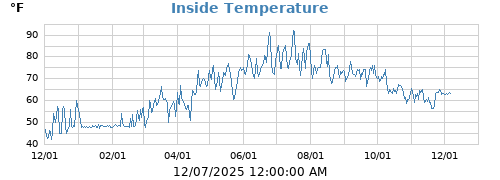
| Inside Temperature |
83.8 74.1 |
83.8 74.1 |
85.5 69.4 |
94.8 57.2 |
94.8 57.2 |
°F |
| Inside Humidity |
84 63 |
84 63 |
85 58 |
87 16 |
87 16 |
% |
Climatological Data
♦
| TODAY | |
| Normal High Temp | 84.1°F |
| Record High Temp | 95.4°F in 2006 |
| Normal Low Temp | 63.8°F |
| Record Low Temp | 50.8°F in 2023 |
| Normal Avg Temp | 73.0°F |
| YESTERDAY | |
| Normal High Temp | 83.7°F |
| Record High Temp | 92.1°F in 2006 |
| Normal Low Temp | 63.7°F |
| Record Low Temp | 52.8°F in 2021 |
| Normal Avg Temp | 72.8°F |
| Avg Temp | 75.9°F |
| Departure From Normal | 3.13F |
| SEASONAL TEMPERATURES | |
| Last Temp Of 32°F | 04/25/2026 06:55:00 AM 99 days, 9 hours, 20 minutes ago |
| Last Temp Of 90°F | 07/09/2026 03:55:00 PM 24 days, 0 hours, 20 minutes ago |
| Climatological Period 2006 To 2025 |
| ☀ | ☽ | |||
|---|---|---|---|---|
| Rise | 5:38 AM | Rise | 9:50 PM | |
| Set | 8:03 PM | Set | 9:44 AM | |
| Daylight | 14:24 | Waning gibbous 83% |
Sensor Status
♦
| Battery Status | |
|---|---|
| Outside T/H | OK |
| Rain Gauge | OK |
| Anemometer | OK |
| Lightning Detector | OK |
| Basement Leak Detector | OK |
| Attic T/H | OK |
| Freezer T/H | OK |
| Garage T/H | OK |
| Dining Room T/H | OK |
| Refrigerator T/H | OK |
| Basement T/H | OK |
| Master Bedroom T/H | OK |
| Latitude | 42° 27.48' N |
| Longitude | 071° 11.73' W |
| Altitude | 161 feet |
| Hardware | ECOWITT Temp WH32EP Rain WH40H Anemometer WS68 Lightning WH57 |
| PurpleAir PA-II-Flex1,2 |
|
| Server Uptime | 1 day, 8 hours, 51 minutes |
| WeeWX Uptime | 0 days, 0 hours, 18 minutes |
| GW2000 Gateway Uptime | 37 days, 2 hours, 43 minutes |
| GW2000 Gateway Memory | 129 KB |
| WeeWX version | 5.4.0 |
| Skin | Pauland 5.4.0 |
| 1 | EPA Correction Applied |
| 2 | EPA Final AQI Update |
Wx Networks Uploaded To
♦
| CWOP | N1OTX |
| Mesowest | AP564 |
| PurpleAir | Pauland.net |
| PWSWeather | KMAWOBUR2 WX |
| WOW | Woburn Weather Center |
| Weather Underground | KMAWOBUR2 |
History:
Day
Week
Month
Year


This station is controlled by WeeWX, an experimental weather software system written in Python.